Marine Consulting
KCS provides a wide range of marine engineering & consulting service based on various technologies relating to the submarine cable installation and maintenance.
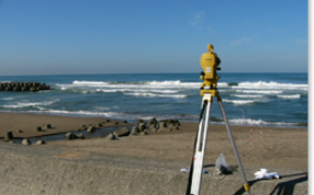
Surveys on Submarine Cable Landing Points
Support of a cable landing place selection by information of geographical conditions and fishery operations based on on-site surveys.
Submarine Cable Route Design and Selection
Totally support a desk research on submarine cable routes, ocean surveys and a route selection after the surveys.
Localization of Submarine Cable Failure Points
Perform a localization of submarine cable failure points in such places as insides of manholes, or as an extremely shallow area where it is difficult to specify the failure point. The localization contributes to the prompt recovery of the submarine cable failures.
Design for Marine Construction Plan
Design a construction plan for installation and protection of cable systems both in a see section and a land section, responding to customer's needs.
Land Conduit Construction Design
Propose a land conduit construction design matching to various environments, such as conduit construction adopting a jacking method.
Design of Submarine Cable Grounding Facilities
Propose, based on our experiences, an appropriate ground design by carrying out preliminary surveys(example: boring) on submarine cable grounds for communication and power supply.
Support for Licensing Procedures
Support for licensing procedures or act as an agent by doing necessary documentary arrangements for the application to the authorities concerned.
Support for Fishery Negotiations
Support for fishery negotiations or act as an agent doing from necessary documentary arrangements to explanations to fishermen.
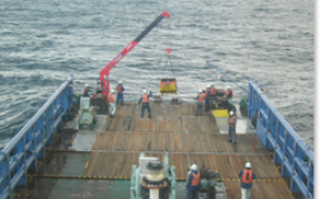
Marine Survey & Measurement
By using the latest survey systems and underwater robots, KCS carries out marine surveys with precision and cost-efficiency. We offer various kinds of surveys, responding to wide range of customers' needs, from surveys and measurement for installation and removal to scientific marine surveys and an environmental investigation.
Coastal and Harbor Measurement
Measure control points of coastal areas and harbor areas, a coast line and a ground height, etc..
Wide-area Surveys on Ocean Floor Topography
Carry out surveys on a bathymetric feature and ocean floor topography by depth measurement and bottom sampling. And select suitable submarine cable laying routes.
Surveys on Fishery Resources and Marine Biology
Support surveys on fishery resources and marine biology by divers.
Environmental Assessment
Support environmental assessment through bottom sampling on the seabed.
Undersea Photographing
Carry out undersea photographing and surveys on the seabed by divers.